Forums › Archives › Archives 2006-2010 › long walk
- This topic has 11 replies, 5 voices, and was last updated 18 years, 3 months ago by
 SCOTT EVANS.
-
AuthorPosts
-
2008-01-06 at 1:35 am #40089
 SCOTT EVANS
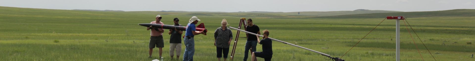
In case any of you at the Launch, were curious, where I was gone for 2 1/2 hours today, fording Snow Drifts and the Elements, I Looked it up at home on Google Earth.
The fence line the Rocket landed next to, is about 1.65 miles strait east of the launch site. Run a perpendicular line north along the fence .9 miles, to the wash that runs south east though the fence line and thats where it was. 1.9 miles north east of the launch.
.8 miles further than Jon Skubas was at the end of the road (If Jon would have been using his Clairvoyante Powers instead of his Radio Beacon, he could of drove right to his).
After rounding the right hill in the right spot, there it was 200-250 yards away (just as clear as A Black Rocket Laying In White Snow With An Orange Parachute). Still took me another 20 Minutes to get to it (Hell, County Rd 77 was only half the distance than back to the Launch site).
I figured I covered about 3.5-4 miles through the Snow and Drifts, before Jon picked me up in the truck,at the end of the road, saving my butt from another mile and a half walk.
Hey Bruce, I might look back more seriosly at that duel deploy for next month.Told Joe, I should get two L2 Certs for that effort.
And Mike, what was the GPS thing you had in your Rocket? Some one told me it was Secret Government Equipment, not availible to just any Roketeer.
Scott (the fat old tired guy) Evans
2008-01-06 at 3:04 am #46328Jeffrey Joe HintonModeratorI know Scott will sleep well tonight. As will Mike Konshak and Greg Arend. 14 flights today, three of which were L2 Certs!!!
2008-01-06 at 5:06 am #46329Warren B. MusselmanModeratorCongrats to the folks that cert’d today. While I wanted to fly, I just didn’t feel like trudging across the rapidly melting snow drifts. Instead, I worked on my L3 project that finally found it’s name today. You’ll figure it out when you see it at MHM.
Warren
2008-01-06 at 5:29 am #46330Bruce R. Schaefer
Scott, Mike, and all who certed today, heartfelt congratulations! To do it is an accomplishment in and of itself, but under those conditions (a bit windy?), you have not only my congrats but respect as well. Dedication! 8)
2008-01-07 at 9:16 am #46331slipstick
Thanks for the congrats. I’m very excited to reach level 2, and especially that my expiremental GPS continued to work after the launch and the drogue chute only recovery. We expected it it to be very windy but for the 1st three hours it was dead calm and a comfortable temperature.
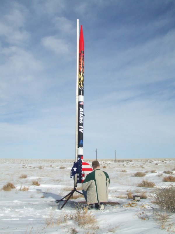
Greg Arend prepping his Atlas IV:

http://www.telerover.com/rockets/AtlasIV_Launch.AVI 120MB file of Atlas IV launchMe talking to Slipstick HP2:
http://www.telerover.com/rockets/Slipstick_HP2_Launch.AVI 61MB file of Slipstick HP2 launchMy 9 lb rocket, Slipstick HP2, achieved 3280 feet in altitude on a J350 and landed 880 yards aways (per the GPS). It was over the eastern horizon but the signal was still strong at the launch site. The rocket transmits on FM at 2W on a folding dipole antenna (about 38″ long (or a half-wave), which is spring loaded (made of .020 music wire) to fit into the airframe. It pops out straight on both sides after the drogue deploys.
Joe Hinton helped me ground test it earlier to 7-1/2 miles (from Louisville to I-25), so its encouraging. I think I can package it so it will fit in a 38mm tube, but right now its in a 3″ airframe, but workable to 54mm. The handheld GPS (see picture – rocket is off in the picture) can track multiple rockets, so and individual would only need to buy the transmitter part, which involves about $250 in parts.
This is going to be my NARAM-50 research entry and I want to write a magazine article, so let me make sure everything is tested (especially for the high G launches) before I give everyone the details. I put some pictures of part of the avbay as a teaser. You’ll see half of the antenna sticking out of the snow, still transmitting:
2008-01-07 at 9:23 am #46332Bruce R. Schaefer
Okay, you guys are just too freakin’ good! Excellent, beyond all means!
2008-01-07 at 2:38 pm #46333SCOTT EVANS
Mike, in order for that hand held unit to point in the right direction, wouldnt you have to have a GPS in the Rocket and in the reciever as well?
I mean, the reciever needs to know where it is in relation to the Rocket doesnt it?
I was to busy traveling to pay to much attention to anything else that day. 😉Scott e
2008-01-07 at 5:24 pm #46334slipstick
Mike, in order for that hand held unit to point in the right direction, wouldnt you have to have a GPS in the Rocket and in the reciever as well? …
Scott e
Scott,
Correct. The rocket has its own GPS (picks up 5 satelites) and transmits the location, relative ground speed and other system data like battery power, in a burst once every 5 seconds using the FM transmitter. The handheld is just a receiver to get the data, it does not transmit back, however it displays the (ground) track from launch to landing. You can slide the pointer arrow over to the last known position to get the coordinates to put into your buddy’s less expensive GPS to send him on his way.
Since FM is line-of-sight, I expected to lose the transmission once it was on the ground like other radio tracking systems, (however it was still being received just fine, so that was cool) so the beauty of this system is that it remembers the last known location (in the air above ground) so finding the rocket should be very easy after that (as long as the GPS stayed with the rocket).
Because the FCC restricts the data transmission to no less than once every 5 seconds. this cannot be used for trajectory tracking, but once under deployment, when it is moving slow, it is very accurate. I forgot to notice what the ground speed was ( I was too excited watching the flight) as that would have told us what the winds were at altitude and the direction, which may have been helpful in locating your rocket. Slipstick’s track showed that it actually reversed direction (wind shear) once it got closer to the ground.
I’m going to make a more compact version that can be quick- linked into anyones rocket (3″ and above) at the site and deployed along with your drogue, if you wish. I don’t think there is enough money to be made with this, so my research will ultimately be provided free to the rocket community (unless someone wants it prepackaged by me).
2008-01-07 at 5:40 pm #46335Warren B. MusselmanModerator2 Watts is an enormous amount of power for HPR telemetry and direction finding. Most commercial rockets use 5W or less for ranges up to 70 miles line of site. Once you get above 250mW, you get into serious issues regarding licensing no matter what frequency band or transmission mode. My 250mW telemetry package readily handles 2400 baud at 7 miles and in good conditions can do almost 56K baud at that same range if I have a clear line of site. 2W is way overkill, but at the same time probably the only reason you got a clear signal once it hit the ground.
Warren
2008-01-08 at 12:29 am #46336SCOTT EVANS
Mike, in order for that hand held unit to point in the right direction, wouldnt you have to have a GPS in the Rocket and in the reciever as well? …
Scott e
Scott,
Correct. The rocket has its own GPS (picks up 5 satelites) and transmits the location, relative ground speed and other system data like battery power, in a burst once every 5 seconds using the FM transmitter. The handheld is just a receiver to get the data, it does not transmit back, however it displays the (ground) track from launch to landing. You can slide the pointer arrow over to the last known position to get the coordinates to put into your buddy’s less expensive GPS to send him on his way.
Since FM is line-of-sight, I expected to lose the transmission once it was on the ground like other radio tracking systems, (however it was still being received just fine, so that was cool) so the beauty of this system is that it remembers the last known location (in the air above ground) so finding the rocket should be very easy after that (as long as the GPS stayed with the rocket).
Because the FCC restricts the data transmission to no less than once every 5 seconds. this cannot be used for trajectory tracking, but once under deployment, when it is moving slow, it is very accurate. I forgot to notice what the ground speed was ( I was too excited watching the flight) as that would have told us what the winds were at altitude and the direction, which may have been helpful in locating your rocket. Slipstick’s track showed that it actually reversed direction (wind shear) once it got closer to the ground.
I’m going to make a more compact version that can be quick- linked into anyones rocket (3″ and above) at the site and deployed along with your drogue, if you wish. I don’t think there is enough money to be made with this, so my research will ultimately be provided free to the rocket community (unless someone wants it prepackaged by me).
I assumed the rocket had a GPS. My question, was there one in the reciever? Which I think you answered. Otherwise it wouldnt know which way to point.(unluss it was just a plain old radio beacon)
Its got to be one of the coolest things Ive seen !!!Above you wrote: Because the FCC restricts the data transmission to no less than once every 5 seconds. Did you mean no more (or more often)
than once every five seconds?scott e
-
AuthorPosts


- The forum ‘Archives 2006-2010’ is closed to new topics and replies.