Forums › NCR Members Area › Lost and Found › Two-Stage – Sustainer Fin can 54mm motor MIA –> FOUND!
- This topic has 23 replies, 6 voices, and was last updated 17 years, 10 months ago by
 slipstick.
-
AuthorPosts
-
2008-05-08 at 5:03 am #47821
 slipstick
How far into the flight did the Sustainer motor ignite and how long would it have gone for after the separation?
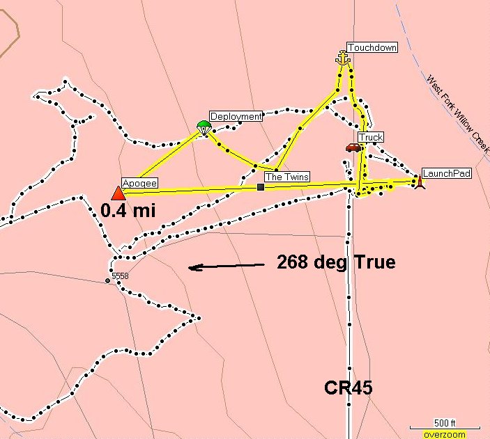
It looked like to me that after it coasted a bit, it started falling flat and spinning. I think it went further to the west than I was first thinking. The angle we were at would put it closer to NW-NE/4 of Section 28 not 27.Greg, I downloaded the GPS info. Here’s the tracks, the last has a 2 mile line extended on the original. The white track is where I walked with the handheld. It appears I misread the vector out on the range and walked in a line created by the falling sustainer before main deployment. Ian and I walked about 20 degrees too far south. We walked 2.2 miles out then got picked up by Becky (the cell phone was working) in the truck who took us back on the road.

Fullsize PDF:http://www.telerover.com/rockets/MS/TheTwinsTrack.pdf
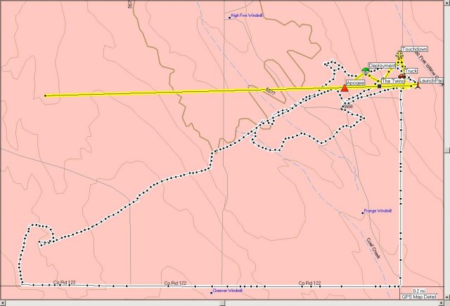
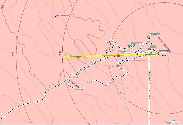
Fullsize PDF:http://www.telerover.com/rockets/MS/TheTwinsTrack3.pdfThe apogee mark (of the Dc20), which is actually the separation point, is at N40 53.158 W104 38.696 0.4 miles from the pad, however the pictures show that the MIA part continues up and way. The Ground Speed from launch to the apogee mark was 144 mph. Assuming that The real apogee was at 0.5 mi, then the MIA fin can should be about twice that distance or 1 mile away, about the distance to the High Five Windmill. But… if the fin can stayed aerodynamic, it may be further, a lot further.
Fullsize PDF:http://www.telerover.com/rockets/MS/TheTwinsTrack4.pdf2008-05-08 at 3:26 pm #47822muleParticipantThanks for the maps, those will really help. I love the technology we have to use now, it makes things so much easier. The pictures are outstanding, talk about pinpoint accuracy – WOW.
My plan of attack is to get on top of the little ridge with a high power spotting scope and do a thorough coverage of the area first. The vegetation is low enough that at that angle I should be able to see a lot on the ground. I can do a go-to track on my gps to look at anything that sticks out. I love stuff like this, the challenge is like a couple mugs of coffee.
I’m hoping I com across some other free ranging birds too, who knows….
Greg
2008-05-08 at 11:35 pm #47823Bruce R. Schaefer
Remember that it may have “lawn darted,” so you may not see it clearly enough. Mike, if you could just provide a little more information… Ha! You are so cool. 😉
2008-05-09 at 2:48 am #47824muleParticipantRemember that it may have “lawn darted,” so you may not see it clearly enough. Mike, if you could just provide a little more information… Ha! You are so cool. 😉
I don’t think it did, I saw it flat rolling for a bit. But, who knows what really happened…. My eyes aren’t always the best, that’s why I’m taking my old friend Bariska with me 😛
Mike’s info reads like that new Apogee newsletter, only more of it. The pictures of the loading process are just amazing.
G2008-05-09 at 3:11 am #47825Bruce R. Schaefer
Mike’s info reads like that new Apogee newsletter, only more of it. The pictures of the loading process are just amazing.
That’s why Mike has 25 patents, 11 pending. I was standing with him, and I never saw it fall… just the fact that it was gone when I recovered the sustainer. Listen, good luck in finding it. Mike, see what kind of club this is?
2008-05-09 at 10:41 pm #47826slipstick
Greg, You are too cool to want to do this. I’m going to try and get up there and join you. What time will you be there? Can you give me your cell phone #
Mines 303-921-8709
[FYI, Bruce, That’s 26 Patents now, 11 pending – I’m going to have to adopt you 8) The title of the my latest submission is “Thermal Transfer Technique using Heat Pipes with Integral Rack Rails”. ]
2008-05-10 at 2:23 am #47827muleParticipantI am going to try and get up at 4am and be there around 6:30.
I have a long day and wanted to spend a couple of hours up there at least, possibly more if I’m having a good time wondering around the place…..FYI, I’m going to try two methods. One will be take a heading off the spot where I was standing while watching and the other is a heading from the approximate separation point. It appears to me there is a small “U” shaped ridge line trending NW/SE w/ the opening to the NW. If I can get to a high enough point with the spotting scope, I’m hoping to better my chances.
PS, I’m a Geologist plus find search and recovery missions to be of the best fun. So, that being said, this is a serious but extremely fun outing for me and you don’t have to feel obliged to come up. BUT, four or more eyes are better than my two+1. 😛
My cell is 303-916-7051 I drive a charcoal Grey, Dodge 4×4 truck.
Greg2008-05-11 at 3:24 am #47828muleParticipantWell,
I’m a bit embarrassed and bummed as well. I was not aware that the fence at about 1 mile to the west of the launch site is not a private property boundary. So, I did not cross it. My GPS tells me that I did manage to cover about 6 miles on the west side and 1.5 miles on the East side. Lots of walking for 3 hrs of time. I did cover the area roughly 200 yards south of the flight line up to and past the fence to the north. I did get to look at that valley to the west of the fence, but did not see it. The spotting scope was a big help. I managed to see a 12″ orange shute back on the east side of the road about 1.5 miles away.If someone has a map showing the private boundaries it would help.
Greg
2008-05-11 at 5:43 am #47829Bruce R. Schaefer
Greg, I know Mike apreciates it very much. He posted a map of what is and is not private property elsewhere on the site. I think it is under “Raunchers” something or other. Really good of you to do this. You are definitely a new and valued member. 😉
2008-05-11 at 3:47 pm #47830muleParticipantThanks,
I enjoy being out doors and wondering aimlessly 😛 So it was fun for that part of it. I’ll find the map for future trips. It’s hard being up there for the first time, in retrospect, I should have checked the lines first. -
AuthorPosts
- You must be logged in to reply to this topic.